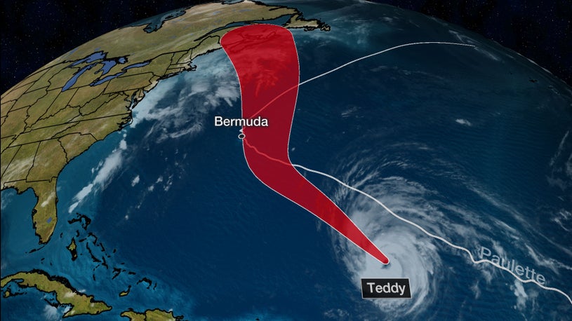
- Hurricane Teddy may pass near Bermuda early next week.
- Strong winds in Bermuda are possible as Teddy passes by to the east.
- After that, Teddy poses an increasing danger to the Canadian Maritimes.
Hurricane Teddy could bring tropical storm conditions to Bermuda just a week after Hurricane Paulette made landfall on the islands, then is an increasing danger for parts of Atlantic Canada next week.
Teddy became the second "major" hurricane - at least Category 3 intensity - of the frenetic 2020 Atlantic hurricane season, Thursday morning.
It then continued to intensify to Category 4 status by late Thursday afternoon, exhibiting a clearing out, warming eye and intense convection with lightning strikes detected by the GOES-East Geostationary Lightning Mapper. A Hurricane Hunter mission found flight-level winds of 143 mph at 10,000 feet above the surface Thursday afternoon.
Given Teddy's current status, its intensity may fluctuate over the next day or so as it replaces its eyewall, a process intense tropical cyclones undergo. It is eventually expected to encounter some increase in wind shear and also the cooler water churned up in the wake of Paulette.
Given the average uncertainty in forecast tracks of National Hurricane Center forecasts, it's too soon to determine the potential impacts, but all interests in Bermuda should monitor the forecast closely and prepare for the potential of another hurricane strike.
Teddy is centered more than 800 miles from Bermuda, but is yet another threat to the islands early next week.
Current Information and Projected Path
(The red-shaded area denotes the potential path of the center of the tropical cyclone. It's important to note that impacts (particularly heavy rain, high surf, coastal flooding, winds) with any tropical cyclone usually spread beyond its forecast path.)Teddy is expected to track within 100 miles of the archipelago early next week, likely as a hurricane.
This should be close enough to bring winds of at least 40 mph to Bermuda and wind gusts of 60 mph are possible.
These winds may not be as bad as those experienced last week when Paulette passed over Bermuda.
This past Monday morning, Hurricane Paulette didn't simply strike Bermuda at Category 1 intensity – its large 35- to 40-mile-wide eye engulfed the entire 20-square-mile group of islands about 650 miles east of Hatteras, North Carolina.
(MORE: What the Forecast Cone Means)
What are the odds of back-to-back strikes on such a tiny part of the Atlantic Ocean? It's happened only once before in Bermuda.
In mid-October 2014, Hurricane Fay was unexpectedly damaging in Bermuda on Oct. 12, followed six days later by Hurricane Gonzalo, which was Bermuda's strongest and most damaging hurricane ($200 million to $400 million in damage) since Fabian in 2003.
Prior to Paulette this year, only eight hurricanes had passed close enough to strike Bermuda since 1970, according to NOAA's historical database.
Atlantic Canada, New England Concern?
Bermuda won't be the final chapter of Teddy.
As with all hurricanes, upper-level winds hold the key to where Teddy will track.
The combination of an area of high pressure aloft over the central Atlantic and a sharp southward plunge of the jet stream over the Northeast U.S. this weekend won't allow Teddy to take a more typical, sharp northeastward "recurve" into the open Atlantic Ocean.
It's far too soon to determine Teddy's exact path next week, but there are a few scenarios.
1. Teddy is diverted far enough north to bring significant impacts to at least parts of the Canadian Maritimes, particularly Nova Scotia and Newfoundland. (Chance: High)
2. The upper trough digs south strongly enough to slingshot Teddy toward the northwest, potentially bringing it closer to parts of coastal New England. (Chance: Low)
3. Teddy remains well east of New England, and just far enough offshore to simply graze parts of coastal Nova Scotia and Newfoundland (Chance: Very Low)
The potential steering winds for Teddy
Eventually, Teddy will transition from a hurricane to an "extratropical storm" as it moves north of the Gulf Stream, gets a boost from the jet-stream plunge to its west and combines with a cold front diving south off the Eastern Seaboard.
With that boost from the jet stream and cold front, it will remain a formidably strong storm next week, regardless of what meteorologists call it.
As that happens, though, its wind field will also expand the farther north it tracks.
This means even if Teddy steers well clear of the U.S., Teddy and the diving cold front will be major wave generators for the Eastern Seaboard, from the east coast of Florida to Maine beginning as soon as this weekend. Large swells are currently affecting the Lesser Antilles and the northeastern coast of South America and will also spread to parts of the Caribbean and the Bahamas by this weekend.
Wave Height Forecast
The National Weather Service is already forecasting at least minor coastal flooding at high tide this weekend from New Jersey to North Carolina.
For now, interests in Atlantic Canada and New England should monitor the forecast for Teddy and have their plans ready in case the storm becomes a threat.
The Weather Company’s primary journalistic mission is to report on breaking weather news, the environment and the importance of science to our lives. This story does not necessarily represent the position of our parent company, IBM.
"strike" - Google News
September 17, 2020 at 06:50AM
https://ift.tt/3iFe8vT
Hurricane Teddy Could Sideswipe Bermuda Just One Week After Paulette's Strike, Then Threaten Atlantic Canada Next Week - The Weather Channel
"strike" - Google News
https://ift.tt/2WheuPk
https://ift.tt/2VWImBB
Bagikan Berita Ini


0 Response to "Hurricane Teddy Could Sideswipe Bermuda Just One Week After Paulette's Strike, Then Threaten Atlantic Canada Next Week - The Weather Channel"
Post a Comment