What to Know
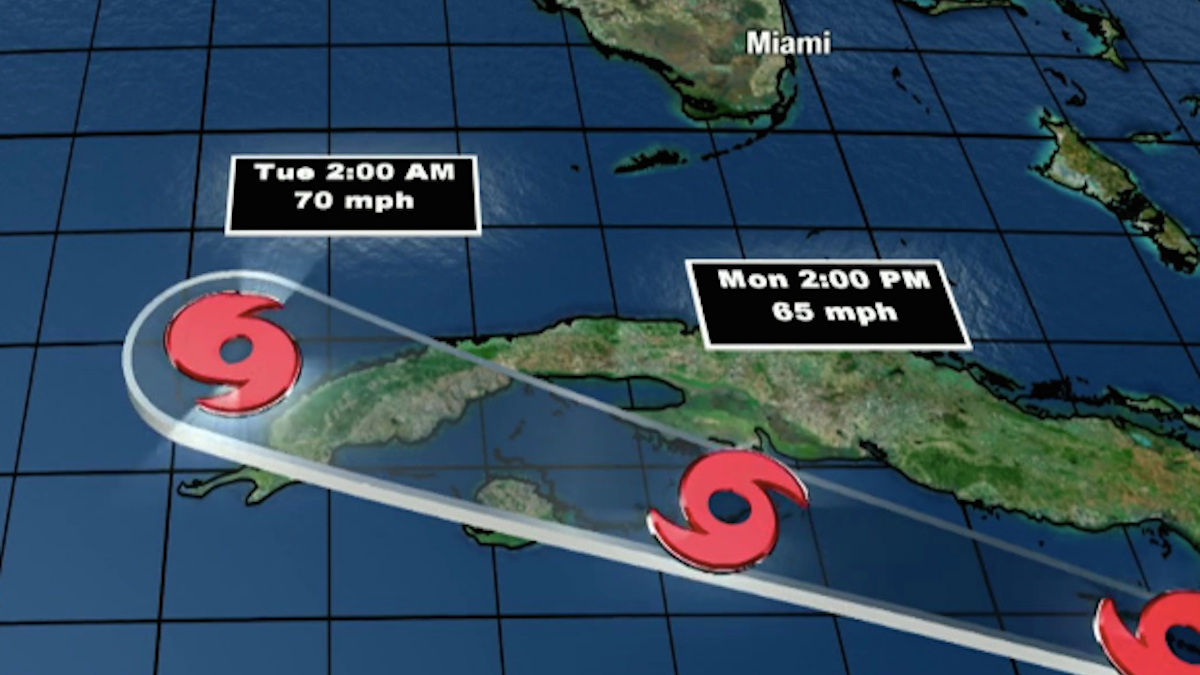
- The 8 a.m. advisory shows the system has winds of 65 miles per hour
- A tropical storm warning has been placed from Key West northward to near Marathon
- Laura caused the deaths of at least 11 people in the Dominican Republic and Haiti
Parts of the Florida Keys remain on guard while Tropical Storm Laura continues to churn south of Cuba early Monday morning.
The 8 a.m. advisory shows the system has winds of 65 miles per hour while currently 125 miles east-southeast of Cayo Largo, Cuba, according to the National Hurricane Center, and moving west-northwest at 21 m.p.h.
A tropical storm warning has been placed from Key West northward to near Marathon, areas that could expect tropical storm force winds and heavy rainfall starting as early as Monday morning.
Stay up to date with NBC 6 First Alert Weather and South Florida's most powerful radar First Alert Doppler 6000 by downloading the NBC 6 app for iOS or Android.
Tropical storm warnings are also in effect for the Little Cayman and Cayman Brac, portions of Cuba as well as the Dry Tortugas.
Monroe County ended its partial evacuation Sunday after Laura's projected path moved away from the islands. Emergency managers said boats, mobile homes, recreational vehicles, trailers and campers are no longer being asked to leave the island chain.
NBC 6's Jamie Guirola spoke with tourists and county officials, who urge everyone to remain on guard for what could be a wicked Monday with the weather.
They are recommending that those who live on boats find shelter on land as seas are expected to be rough as Laura passes to the west into the Gulf of Mexico. They also asked that those who had already evacuated wait until Tuesday before returning.
The National Weather Service says the Keys will see severe weather, isolated tornadoes, and coastal flooding three to six inches higher than king tides, especially on the Atlantic side. Residents and visitors should be aware of hazardous weather conditions in the Florida Keys starting Monday morning through Tuesday morning.
“Residents should continue to monitor the storm and be prepared for severe weather, 20-30 mph winds with gusts up to 50 mph, and strong squalls,” said Shannon Weiner, Monroe County Emergency Management Director. “Please secure all boats and outside items by this evening for this event.”
Laura was forecast to move along Cuba's southern coast during the day before entering the Gulf of Mexico and heading toward a stretch of U.S. coast later in the week, most likely as powerful as a Category 2 hurricane.
Laura caused the deaths of at least 11 people in the Dominican Republic and Haiti, while knocking out power and causing flooding in the two nations that share the island of Hispaniola.
Haitian civil protection officials said they had received reports a 10-year-old girl was killed when a tree fell on a home in the southern coastal town of Anse-a-Pitres, on the border with the Dominican Republic. Haiti's prime minister said at least eight other people died and two were missing. In the Dominican Republic, relatives told reporters a collapsed wall killed a mother and her young son.
Hundreds of thousands were without power in the Dominican Republic amid heavy flooding in both countries.
Meanwhile, Tropical Storm Marco is expected to continue to head across the Gulf, reaching more strength when it approaches the northern Gulf Coast Monday. The storm will then slow down and move west Monday night, across southern Louisiana and into eastern Texas.
The 8 a.m. advisory has winds of 50 m.p.h. while the center sits just over 130 miles per hour south-southeast of the mouth of the Mississippi River and moving northwest at 10 m.p.h.
A Hurricane Watch was in effect from Intracoastal City, Louisiana to west of Morgan City and Metropolitan New Orleans. Forecasters predict life-threatening storm surge and hurricane-force winds along portions of the U.S. Gulf Coast.
If both storms survive the until Monday, the National Hurricane Center forecast that Laura would as head a hurricane toward the central Gulf Coast around Louisiana, Mississippi, Alabama and the western Florida Panhandle, while Marco aimed at Texas.
“A lot of people are going to be impacted by rainfall and storm surge in the Gulf of Mexico,” said Joel Cline, the tropical program coordinator for the National Weather Service. “Since you simply don’t know you really need to make precautions.”
Two hurricanes have never appeared in the Gulf of Mexico at the same time, according to records going back to at least 1900, said Colorado State University hurricane researcher Phil Klotzbach. The last time two tropical storms were in the Gulf together was in 1959, he said.
"strike" - Google News
August 24, 2020 at 06:55PM
https://ift.tt/32n6Vt9
Lower, Middle Keys Under Tropical Storm Warning as Laura Prepares to Strike Cuba - NBC 6 South Florida
"strike" - Google News
https://ift.tt/2WheuPk
https://ift.tt/2VWImBB
Bagikan Berita Ini


0 Response to "Lower, Middle Keys Under Tropical Storm Warning as Laura Prepares to Strike Cuba - NBC 6 South Florida"
Post a Comment